|
Physical
Conditions in Canada
Precipitation
| Temperature | The Arctic Circle
| Geology and geography
Precipitation
In the northern hemisphere, winds generally blow from west to east, and
this has a major impact on Canada's climate. Winds coming off of the Pacific
Ocean are extremely humid. When they come inland, they find the Rocky
and Coastal Mountains, and rise to get over them. As the clouds rise,
they cool off at the higher altitudes, which causes the moisture they
carry to fall as rain or snow, a phenomenon known as orographic precipitation.
In this way the west coast gets its high annual rainfall while the prairies
just to the east of the mountains get very little, as the air is dry by
the time it makes it over the mountains.
 There
are two other sources of air which affect precipitation in the rest of
the country. Air coming from the arctic is cold and dry, while air coming
from the Tropical Stream and the Gulf of Mexico is warmer and moist. These
three air systems cover different parts of the country during the year,
but each affects the precipitation. There
are two other sources of air which affect precipitation in the rest of
the country. Air coming from the arctic is cold and dry, while air coming
from the Tropical Stream and the Gulf of Mexico is warmer and moist. These
three air systems cover different parts of the country during the year,
but each affects the precipitation.
The dry arctic air makes the
north and central regions of the country dry, while most of the moisture
in southeastern Canada is from the tropical air stream in the Atlantic,
which enters the country from the south.
The east coast gets more precipitation
not so much because of the Atlantic Ocean, as the winds are still blowing
to the east, but because the Arctic and Tropical Streams meet in the area,
causing much precipitation.
Temperature
Oceans not only provide much of the precipitation that falls in the country,
but also help to keep temperature fluctuations down. The effect of the
oceans is to make the coasts' winters warmer and summers cooler. In the
interior of the country the temperatures vary much more during the seasons,
between seasons, and from year to year as well. The coldest temperature
recorded in Canada was -63ºC in Snag, in the Yukon Territories, February
3rd, 1947.
The Arctic
Circle
Located at a latitude
of 66º33' north, the Arctic Circle is the southernmost location at which
the sun does not rise on the winter solstice or set on summer solstice.
The closer one is to the North Pole, the longer the dark or light period
is. These periods are known as the Polar Night and Midnight Sun, respectively.
Geology
and Geography
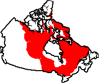 Made
up of some of the oldest rock in the world, the Canadian Shield is the
heart of the continent. It makes up roughly half of Canada's land mass.
On the map to the right, the Canadian Shield is shown in red. Made
up of some of the oldest rock in the world, the Canadian Shield is the
heart of the continent. It makes up roughly half of Canada's land mass.
On the map to the right, the Canadian Shield is shown in red.
Three major mountain ranges
are found in Canada. Two of them, the Rocky Mountains and Coastal Mountains,
are both found in the west, while the arctic cordillera runs along the
northeastern edge of the country. Older eroded mountains can be found
in Quebec, but these are nowhere near as tall as the newer ranges mentioned.
Most of the rest of the country has flat or rolling terrain.
The igneous granite of the
Canadian Shield is often exposed to the north, but is less so to the south.
Sedimentary rock makes up the bedrock of the Rocky mountains and the plains
to the east of them, while the Coast Mountains are igneous and metamorphic
in origin. The Atlantic provinces contain both igneous and sedimentary
rock.
Southern Ontario and Quebec,
the Prairies, and the valleys of the Atlantic Provinces have the most
productive soil in the country. In the north soil takes the form of permafrost,
where the water in the ground is permanently frozen. Permafrost blocks
the flow of water and causes bogs.
More details can be found
in the descriptions of each ecozone.
 
|